
The MyInfo Upload Tool enables you to Upload and tag multiple user points, or upload multiple tags for existing elements in the DI system. You can upload user points with or without tag data (name. category, unit, and value), or rather than creating your own user points you may upload data to tag existing elements in the DI system.
Before uploading your data you must prepare your file.
First put your data in a spreadsheet if it is not in one already.
For a location reference, your data can have either:
API Numbers
Lat - longs (NAD 27, dd.dddd format, with longitude a negative number)
A combination of API Numbers & lat - longs
c. Organize your data in your spreadsheet.
For API Numbers only, put API’s in the 1st column, name (example: tops) in the 2nd column.
For lat-longs only, put the latitude in the first column, longitude is in the 2nd column, and name (example: tops) is in the 3rd column.
For API’s & lat-longs, put latitude in the first column, longitude in the 2nd column, API’s in the 3rd column and name (example: tops) in the 4th column.
You’re now ready to upload your file.
The first step in using this tool is to provide information regarding lat/longs and API data in your upload. You may choose to upload data containing lat/longs, API #'s or both.
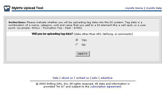
On the next page you must indicate whether you will be uploading tag data. Tag data is a combination of a name, category, unit and value that you add to a DI element like a well spot, or a user point. (example: Wilcox - Formation Top - Feet - 8700).
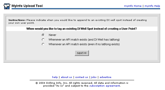
On the next page you will indicate when you would like to append to an existing DI well spot instead of creating your own user point, this where you determine if you will be tagging existing DI elements or creating new User Points.
The final page in the upload process is where you specify how data in your upload file is arranged. If uploading tag data, you will need to select a template to use for the upload. You must also specify how your API is formatted in your upload file and whether you would like to overwrite existing User Points or tags with matching APIs. You will choose a comma or tab delimiter method and also whether you would like to add comments. And finally you may copy/paste your data directly into the form or upload a file.
