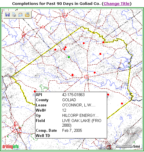
Completions for the time period you selected will display on the map as green dots (oil) and red dots (gas) or aqua (Both oil and gas, neither oil nor gas, or unknown). When you place your cursor on an oil or gas completion, or dot, a hover box will appear that gives you a quick summary of the completion data, as shown in the example below:
If you want to know more about the completion, click on the well or dot, and a Completion Summary pop-up window will appear that will allow you to find out more about the completion. An example is shown below:
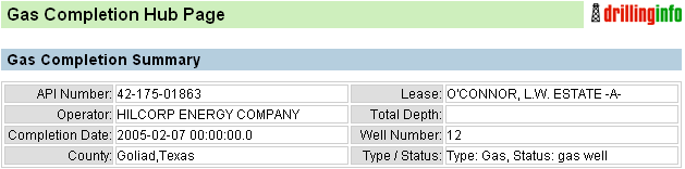
A description of the links in the Completion Summary follows:
Permit Detail - Reproduces a facsimile of the permit that is associated with this completion
Completion Detail - Reproduces a facsimile of the oil or gas permit associated with this completion. The top portion of a sample gas completion is shown below:
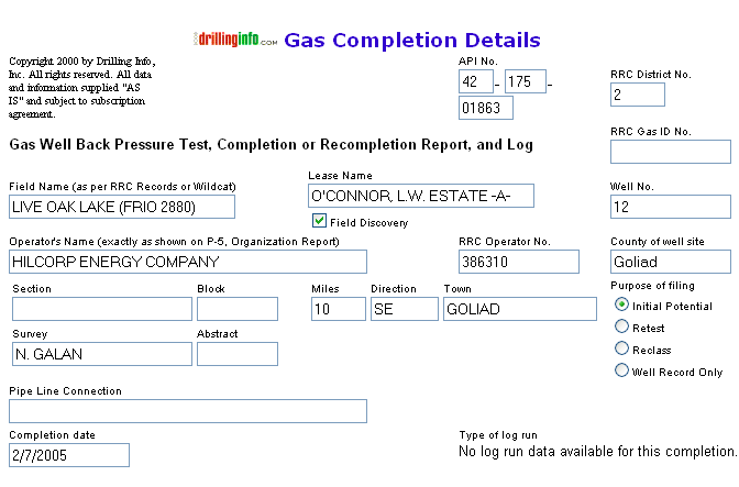
The bottom portion of the Completion Detail includes casing, perforation, formation, treatment information, etc.
Note: For wells completed before May 15, 2000 oil and gas initial potential test data may not be available. We suggest that you go to the production database and recover the first full month's production for the well. We believe that this is a more realistic measure of the well's producing capacity. Wells completed prior to May 15, 2000 that have not been plugged may also have only partial perforation information. For any well completed after May 15, 2000, you can recover all information contained on oil and gas initial potential tests.
Well History / One-Page Prod Summary - Takes you to the Well History/ Production Summary Hub. For a further discussion of the different links, see Production Maps.
Related Filings - Shows other permit, completion and/or test information associated with this wellbore. For further information regarding the permit links, see Permit Maps.
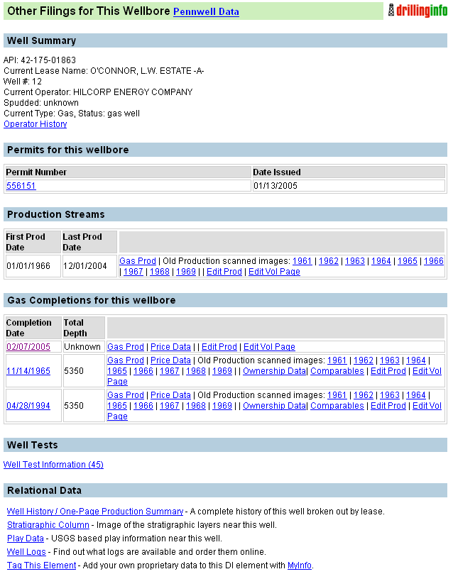
Well History/One-Page Production Summary - Provides links to a page containing basic information about the history of the well, a concise history of the well's production and price data if in Texas.
Stratigraphic Column - A stratigraphic chart keyed to the basin in which the well is located .
Play Data - List of known oil and gas plays in the area of the well, with descriptions for each play.
Well Logs - If DrillingInfo has well logs available for this well, then the related information will appear.
Tag This Element - Allows you to tag this well and attache to a template in My Info.
Here are some tips for the completion maps:
Selecting a title for your map that states your search parameters (i.e. Goliad, Permits, 9/1/02-10/31/02) allows you to identify maps that you print.
Remember the Search Status Box to the left of the map allows you to track how much of the data you requested is being displayed. Searches that find more than 250 items will be truncated according to predetermined criteria. The criteria you can choose are either depth or county. To display the rest of the data, initiate a new search using the same criteria as the initial search but enter the deepest depth of the truncated data set plus one foot. For example, if you choose Depth as your truncation criteria, and permits from 0-7530 were displayed, start your new search with depths of 7531 and deeper.
After clicking on point or API and entering various hubs, use your back button on the browser to return to a previous section.
See Map Help for more information.