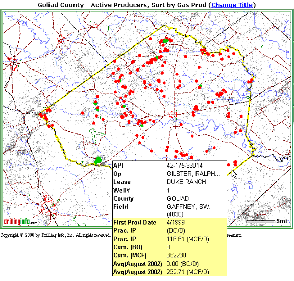
The first map you see will include the wells that you searched for and the area that encompasses them. The dots are colored: green dots (oil) and red dots (gas) or aqua (Both oil and gas, neither oil nor gas, or unknown). In highly drilled areas, this initial map will also show small black dots. These small black dots represent oil and gas wells that are in your search area, but which were not a part of your search criteria.
Placing your cursor over a well, or dot, will generate a pop-up hover window with summary production information. This hover box is similar to those on the permit and completion maps, but includes different information. An example is shown below:
If you want to know more about the production, click on the well and a Production Summary pop-up window will appear with the production chart for the well you are examining. An example is shown below:
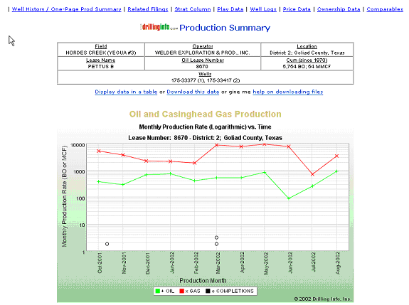
A description of the Production Summary follows:
Property identification data - Field name, Operator, Lease Name, Lease #, Location, Cum, and API #'s of wells contributing to lease production
Production Chart - Major Phases (oil or gas) & Minor Phases (casinghead gas or condensate, respectively)
Re-completions denoted on the production curve - The small black circles in the body of the production graph represent individual completion events in the lease’s or the well’s producing history. This makes it easy to differentiate anomalous reservoir behavior from operator-initiated well activity. Clicking on the circle will give you completion detail information with links to other information.
An individual month’s production can be seen by leaving the cursor stationary over any point on the chart that corresponds to a month.
Download or Display data: See monthly production history presented in table form by clicking on the Display data in table link. Or, download and save the data by clicking the Download this data link.
For further assistance, see Production Download Help
Decline Curve Analysis - Determines decline rate between any two points of major phase production history. See Decline Curve Analysis for further information.
Economic Analysis: Determines decline rate between any two points of major phase production history. Uses decline rate from Decline Curve Analysis, or user input decline rate, as well as other user inputs, to determine estimated future production flowstream, remaining recoverable reserves, net present value profile and other metrics.
Determine decline curve for several field wells at same point in production history to gain insight into reservoir performance; use to identify possible acquisition candidates, or to promptly identify under performing wells in need of workover or divestiture.
See Economic Analysis for further information.
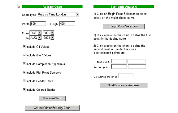
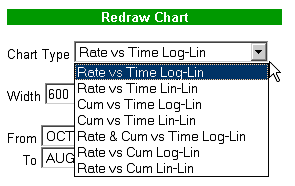
Production Chart customization options - Display options, Time options
Chart Display: The following are the various display options for the production charts.
You may also adjust the width and height of the chart.
Time Options: Modify date of chart to show desired date range
Other display options: You may modify other display features as shown below:

Note: Be certain to select Redraw Chart to see results of your modifications.
Print the chart for report or other purposes by clicking on the Printer Friendly Chart button.
Tip
It’s always a good idea to title your map, especially if you are looking at an area with multiple producing reservoirs.
See Map Help for more information.
See Graphical Analysis Help for more information regarding how to select and analyze multiple wells.
Well History / One-Page Prod Summary – Takes you to the Well History/ Production Summary Hub as shown below:
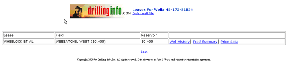
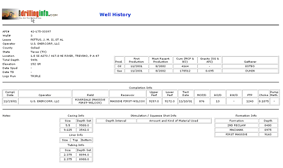
When you select Well History, you will get a summary of the well information including API#, Lease, Well #, Operator, county, State, Location, Depth, Elevation, Date spud, Date TD, Logs Run in the header. The Well history displays cumulative oil and/or gas production data as well as summary completion information.
The Production Summary provides a breakdown by month of the previous 12 months’ production and yearly production totals for all previous years as shown below:

The Price Data link takes you to information regarding the sales for the selected well or lease as shown below:
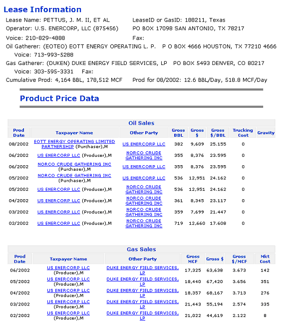
The Price Data includes lease information including Lease Name, Gas or Lease ID, Operator contact information, oil and gas gatherer contact information, cumulative production and average production for latest month. The Product Price information is listed by production month and includes the taxpayer name with contact link, other party with contact link, gross volumes, gross sales, price per unit and any marketing or trucking costs.
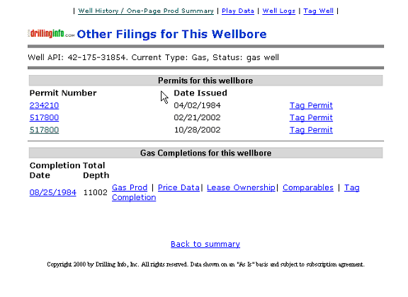
Related Filings - Shows other permit, completion information associated with this wellbore. For further information regarding the Permit and Completion links, see respective sections.
Strat Column - A generalized stratigraphic column for the area.
Play Data - A listing of known plays for this area, with accompanying play descriptions.
Well Logs – If Drillinginfo has well logs available for this well, then the related information will appear.
Ownership and Comparables – Provides links to Black Bart web site. Black Bart data is not part of the Drillinginfo subscription service.